A melting Arctic and weird weather: the plot thickens

By Jennifer Francis, Rutgers University

Everyone loves to talk about the weather, and this winter Mother Nature has served up a feast to chew on. Few parts of the US have been spared her wrath.

Severe drought and abnormally warm conditions continue in the west, with the first-ever rain-free January in San Francisco; bitter cold hangs tough over the upper Midwest and Northeast; and New England is being buried by a seemingly endless string of snowy nor’easters.

Yes, droughts, cold and snowstorms have happened before, but the persistence of this pattern over North America is starting to raise eyebrows. Is climate change at work here?

Wavier jet stream

One thing we do know is that the polar jet stream – a fast river of wind up where jets fly that circumnavigates the northern hemisphere – has been doing some odd things in recent years.

Rather than circling in a relatively straight path, the jet stream has meandered more in north-south waves. In the west, it’s been bulging northward, arguably since December 2013 – a pattern dubbed the “Ridiculously Resilient Ridge” by meteorologists. In the east, we’ve seen its southern-dipping counterpart, which I call the “Terribly Tenacious Trough.” (See picture, below.)

Source: NOAA

These long-lived shifts from the polar jet stream’s typical pattern have been responsible for some wicked weather this winter, with cold Arctic winds blasting everywhere from the Windy City to the Big Apple for weeks at a time.

We know that climate change is increasing the odds of extreme weather such as heatwaves, droughts and unusually heavy precipitation events, but is it making these sticky jet-stream patterns more likely, too? Maybe.

Slowing, drunken path

The jet stream is a dastardly complex creature, and figuring out what makes it tick has challenged atmospheric scientists since it was discovered about 75 years ago. Even more elusive is figuring out how climate change will affect it.

Jet streams exist because of differences in air temperature. In the case of the polar jet stream, which is responsible for most of the weather we experience around the middle-latitudes of the northern hemisphere, it’s the cold Arctic butting against warmer areas to the south that drives it. (A more in-depth explanation can be found here.) Anything that affects that temperature difference will affect the jet stream.

This is where climate change comes in: the Arctic is warming much faster than elsewhere. That Arctic/mid-latitude temperature difference, consequently, is getting smaller. And the smaller differential in temperatures is causing the west-to-east winds in the jet to weaken.

Strong jets tend to blow straight west to east; weaker jets tend to wander more in a drunken north/south path, increasing the likelihood of wavy patterns like the one we’ve seen almost non-stop since last winter.

When the jet stream’s waves grow larger, they tend to move eastward more slowly, which means the weather they generate also moves more slowly, creating more persistent weather patterns.

NASA/Goddard Space Flight Center Scientific Visualization Studio

At least, that’s the theory. Proving it is not easy because other changes are happening in the climate system simultaneously. Some are natural fluctuations, such as El Niño, and others are related to increasing greenhouse gases.

We do know, however, that the Arctic is changing in a wholesale way and at a pace that makes even Arctic scientists queasy. Take sea ice, for example. In only 30 years, its volume has declined by about 60%, which is causing ripple effects throughout the ocean, atmosphere, and ecosystem, both within the Arctic and beyond. I’ve been studying the Arctic atmosphere and sea ice my entire career and I never imagined I’d see the region change so much and so fast.

‘Stuck’ weather patterns

To study the effects of Arctic change on weather patterns, we have good measurements of atmospheric temperatures and winds going back to the late 1970s, when satellites started providing data, and pretty good measurements back to the late 1940s.

My colleagues and I have been using this information to measure the waviness of the jet stream and whether it is behaving differently since the Arctic started its rapid warm-up about 20 years ago. Because the upper atmosphere is such a cacophony of swirling winds, however, measuring changes in the jet stream’s waviness is tricky, as it’s not a metric that scientists have traditionally used.

Our challenge, then, is to find new methods to measure waviness and determine whether any changes we find are related to rapid Arctic warming, to some other change in the climate system, or to just random chance. While the story is still in early days, the plot is thickening.

Several groups around the globe, including my colleagues and me, are trying to understand the linkages between rapid Arctic warming and changes in weather patterns.

A number of recent studies have found what appears to be a solid connection between sea-ice loss in an area north of western Russia during the fall and a rash of abnormally cold winters in central Asia. The loss of sea ice favors a northward bulge in the jet stream, which strengthens surface high pressure to the east. That shift pumps cold Arctic air southward into central Asia.

Other studies suggest that Arctic warming in summer leads to a split jet stream – or two separated rivers of wind – which tends to trap the waves. Those stationary waves cause weather conditions to remain “stuck” for long periods, increasing the likelihood of extreme heat waves, droughts and flooding events in Eurasia and North America.

Our own new work, published last month in Environmental Research Letters, uses a variety of new metrics to show that the jet stream is becoming wavier and that rapid Arctic warming is playing a role. If these results are confirmed, then we’ll see our weather patterns become more persistent.

In other words, Ridiculously Resilient Ridges and Terribly Tenacious Troughs may become the norm, along with the weather woes they cause.

This article was originally published on The Conversation.
Read the original article. Feature photo credits:  Stuart Rankin/Flickr, CC BY-NC

Severe weather around the world

Official blog of the Met Office news team

While the UK is currently experiencing relatively benign weather for the time of year, extreme conditions are expected in some other parts of the world.

Morocco and Spain

Last Saturday, Agadir in Morocco saw 90mm of rain fall in just 24 hours, which is around twice the monthly November average for the region of just 50mm. The subsequent flooding resulted in more than 30 fatalities.

Unfortunately, more severe weather is expected through Friday and into the weekend across Morocco, but particularly around the southwest of the country.

A combination of a deep area of low pressure, relatively warm sea temperatures and strong winds will bring heavy rainfall. 100-150mm of rain could fall across SW Morocco on Friday with further heavy rain likely on Saturday, and totals could be enhanced over higher ground. Conditions should improve into Sunday.

Through the weekend, the same area of low pressure is expected to bring…

View original post 190 more words

Friday Fact – 10th October 2014

hurricane_katrina-NASA

Did you know, hurricanes, cyclones and typhoons are different names for the same weather phenomenon?

In general large cyclonic storms in the Atlantic and East Pacific are called hurricanes, those in the Indian Ocean are called cyclones while typhoons are the same weather events in the western Pacific.

More Information:
[1] Check out our blog post on these incredibly energetic weather events.


Hurricane Odile makes landfall in Mexico

An approximate representation of coastal areas under a hurricane warning (red). Source: NOAA

An approximate representation of coastal areas under a hurricane warning (red).
Source: NOAA, National Hurricane Centre

Tropical hurricane Odile has hit the Los Cabos resort in western Mexico. The category three hurricane made landfall on the southern tip of the Baja California peninsula. Maximum sustained wind speeds are up to 185 km per hour (115 miles per hour) with higher wind gusts. The centre of the storm is currently moving to the NNW at a speed of 16 miles per hour.

The National Oceanic and Atmospheric Administration (NOAA) warns that Odile is a large hurricane with hurricane force winds extending outward up to 85 km (50 miles) from the centre. Tropical storm force winds are expected to extend outward up to 295 km (185 miles).

The hurricane is expected to continue heading NNW up the Baja California Peninsula over the next few days with steady weakening energy.

Hazards:

Wind – Hurricane conditions will continue to spread northward through tonight.

Storm surge – A dangerous storm surge is expected to produce significant coastal flooding.  Near the coast the surge will be accompanied by large and destructive waves.

Rainfall – Odile is expected to produce rainfalls of 15-31 centimetres across much of the Baja California Peninsula through to Friday. These are likely to result in flash floods and mud slides.

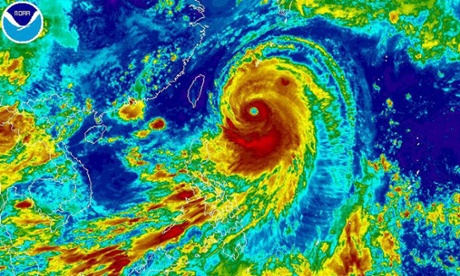
Infrared image of hurricane Odile in its current location. Source: Odile

Infrared image of hurricane Odile in its current location.
Source: NOAA

More information:

[1] Keep up to date with warnings and the status of Odile on the NOAA website:
http://www.nhc.noaa.gov/text/refresh/MIATCPEP5+shtml/141135.shtml
[2] http://www.nhc.noaa.gov/graphics_ep5.shtml?5-daynl#contents


Hawaii prepares for its first hurricane in 22 years

Pacific Hurricane Iselle is due to strike the Big Island of the Hawaii island chain sometime today.

Forecasters initially thought that Iselle would reduce in intensity to a large tropical storm before it hit the island. However weather officials changed their outlook after Iselle became slightly stronger and was able to maintain its hurricane classification.

The island chain is preparing for strong winds and heavy rainfall. This is the first hurricane strength storm to strike Hawaii in 22 years.

Another Pacific storm further to the east, Hurricane Julio, is strengthening and heading towards the island chain. Julio is expected to approach Hawaii closer to the weekend. Forecasters predict that it might pass to the north of the island chain. However the rainfall from two events in such close proximity could result in widespread flash flooding.

Keep an eye on the NOAA website for updates on the storm risks.


Hurricanes Iselle (left) and Juio (right).  Image from NOAA

Hurricanes Iselle (left) and Juio (right).
Image from NOAA


More information:
[1] http://www.bbc.co.uk/news/world-us-canada-28693242
[2] http://www.prh.noaa.gov/cphc
[3] http://www.nhc.noaa.gov/index.shtml?epac

Japan hit by Super Typhoon Neoguri

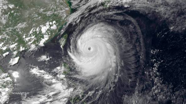
typhoon_neoguriThe violent super typhoon Neoguri is possibly the most powerful typhoon to strike Japan in 15 years. With expected wind gusts of 170 miles per hour and 75 millimetres of rain per hour the typhoon is battering the southern islands of Okinawa this morning.

Neoguri is forecast to continue northwards over land passing over the southern island of Kyushu and onto central Japan slowly losing energy along the way.

Typhoon Neoguri is carrying a huge amount of moisture. When it hits the mainland much of that will be released as rain, which could unleash flash floods and trigger landslides, our correspondent adds. Storm surge wave heights of 12 metres are expected raising fears of further coastal flooding.

Check out one of our earlier posts for a discussion of how these large cyclonic storms form.

Typhoon Neoguri, the first super typhoon of 2014. Source: EPA/NOAA

Typhoon Neoguri, the first super typhoon of 2014. Source: EPA/NOAA


More information:
[1] http://www.bbc.co.uk/news/world-asia-28189409
[2] https://climateandgeohazards.wordpress.com/2013/10/07/cyclones-hurricanes-and-typhoons-whats-the-difference


Video

Twin Tornadoes hit Nebraska, United States

Twin tornadoes are an exceptionally rare weather phenomenon. Two large tornadoes hit the town of Pilger in the U.S. state of Nebraska last Monday, 16th June.

The video above shows the two violent tornadoes ripping through the countryside. The BBC reports that at least one person is dead and at least 19 are hurt.

Check out our earlier post for more information on tornadoes, how they form and how their strength is calculated.

Tornadoes: Rotating Destruction

A tornado is a violently rotating column of air that is in contact with both the surface of the Earth and a large rain cloud.

Most tornadoes have wind speeds less than 110 miles per hour, are about 76 metres across, and travel several kilometers before losing all its energy and dissipating. However, some extreme tornadoes can attain wind speeds of more than 300 miles per hour, stretch more than two miles across, and stay on the ground for more than 100 km!

These violent weather events can rip paths of destruction through towns and cities and kill large numbers of people.

Tornado Formation
Although, no two tornadoes are the same, they all need certain conditions before they can form – particularly intense heat.

Winds from different directions cause the rising air to rotate. Source: BBC

Winds from different directions cause the rising air to rotate.
Source: BBC

  • As the ground temperature increases, warm, wet air heats up and starts to rise.
  • When this warm, moist, air meets cold dry air, it explodes upwards, puncturing the air layer above. At this stage a thunder cloud may begin to build.
  • This develops into a storm – there may be rain, thunder and lightning.
  • Winds from different  directions can case the upward moving air to rotate
  • This forms the characteristic cone shape we associate with tornadoes.

Tornado Strength Scale
There are several scales for rating the strength of tornadoes. The Enhanced Fujita Scale (EFS) rates tornadoes by the amount of damage caused by the tornado. This is the most common rating scale used by most countries.

The Enhanced Fujita Scale splits tornado strength into six categories.

The Enhanced Fujita Scale for tornadoes

The Enhanced Fujita Scale for tornadoes


Tornadoes have been observed on every continent except Antarctica. However, the vast majority of tornadoes occur in the Tornado Alley region of the United States.

Ekbal

More Information:
[1] http://news.bbc.co.uk/1/hi/in_depth/5328524.stm