Up to 80 mile an hour wind gusts possible from ex-hurricane Gonzalo

The remains of hurricane Gonzalo is due to strike the British Isles tonight resulting in widespread rainfall and wind gusts up to 80 miles an hour tomorrow morning.

Gonzalo travelled over the island of Bermuda earlier this week, but has since been decreasing in energy and is now downgraded from hurricane status to an extra-tropical storm. The video below, from the Met Office, shows ex-hurricane Gonzalo undergoing extra-tropical transition into an Atlantic low pressure system.

The Met Office has issued a severe weather warning for wind for large parts of the UK. The worst disruption is expected on Tuesday morning when high wind gusts coincide with the morning rush hour.

The Environment Agency has asked people to be flood aware and prepared, Although the strong winds might help drive low coastal flood risk on Tuesday and Wednesday. You can keep up to date with updated flood warnings on the Environment Agency’s website: http://apps.environment-agency.gov.uk/flood/142151.aspx

floodEkbal

More information:
[1] The Met Office warnings: http://www.metoffice.gov.uk/public/weather/warnings/
[2] The Environment Agency flood risk map: http://apps.environment-agency.gov.uk/flood/142151.aspx
[3] More about hurricanes, typhoons and cyclones: https://climateandgeohazards.wordpress.com/2013/10/07/cyclones-hurricanes-and-typhoons-whats-the-difference
[4] The latest BBC news report at time of writing (21:37 Mon 20th): http://www.bbc.co.uk/news/uk-29685066

Friday Fact – 10th October 2014

hurricane_katrina-NASA

Did you know, hurricanes, cyclones and typhoons are different names for the same weather phenomenon?

In general large cyclonic storms in the Atlantic and East Pacific are called hurricanes, those in the Indian Ocean are called cyclones while typhoons are the same weather events in the western Pacific.

More Information:
[1] Check out our blog post on these incredibly energetic weather events.


Hurricane Odile makes landfall in Mexico

An approximate representation of coastal areas under a hurricane warning (red). Source: NOAA

An approximate representation of coastal areas under a hurricane warning (red).
Source: NOAA, National Hurricane Centre

Tropical hurricane Odile has hit the Los Cabos resort in western Mexico. The category three hurricane made landfall on the southern tip of the Baja California peninsula. Maximum sustained wind speeds are up to 185 km per hour (115 miles per hour) with higher wind gusts. The centre of the storm is currently moving to the NNW at a speed of 16 miles per hour.

The National Oceanic and Atmospheric Administration (NOAA) warns that Odile is a large hurricane with hurricane force winds extending outward up to 85 km (50 miles) from the centre. Tropical storm force winds are expected to extend outward up to 295 km (185 miles).

The hurricane is expected to continue heading NNW up the Baja California Peninsula over the next few days with steady weakening energy.

Hazards:

Wind – Hurricane conditions will continue to spread northward through tonight.

Storm surge – A dangerous storm surge is expected to produce significant coastal flooding.  Near the coast the surge will be accompanied by large and destructive waves.

Rainfall – Odile is expected to produce rainfalls of 15-31 centimetres across much of the Baja California Peninsula through to Friday. These are likely to result in flash floods and mud slides.

Infrared image of hurricane Odile in its current location. Source: Odile

Infrared image of hurricane Odile in its current location.
Source: NOAA

More information:

[1] Keep up to date with warnings and the status of Odile on the NOAA website:
http://www.nhc.noaa.gov/text/refresh/MIATCPEP5+shtml/141135.shtml
[2] http://www.nhc.noaa.gov/graphics_ep5.shtml?5-daynl#contents


Hawaii prepares for its first hurricane in 22 years

Pacific Hurricane Iselle is due to strike the Big Island of the Hawaii island chain sometime today.

Forecasters initially thought that Iselle would reduce in intensity to a large tropical storm before it hit the island. However weather officials changed their outlook after Iselle became slightly stronger and was able to maintain its hurricane classification.

The island chain is preparing for strong winds and heavy rainfall. This is the first hurricane strength storm to strike Hawaii in 22 years.

Another Pacific storm further to the east, Hurricane Julio, is strengthening and heading towards the island chain. Julio is expected to approach Hawaii closer to the weekend. Forecasters predict that it might pass to the north of the island chain. However the rainfall from two events in such close proximity could result in widespread flash flooding.

Keep an eye on the NOAA website for updates on the storm risks.


Hurricanes Iselle (left) and Juio (right).  Image from NOAA

Hurricanes Iselle (left) and Juio (right).
Image from NOAA


More information:
[1] http://www.bbc.co.uk/news/world-us-canada-28693242
[2] http://www.prh.noaa.gov/cphc
[3] http://www.nhc.noaa.gov/index.shtml?epac

Japan hit by Super Typhoon Neoguri

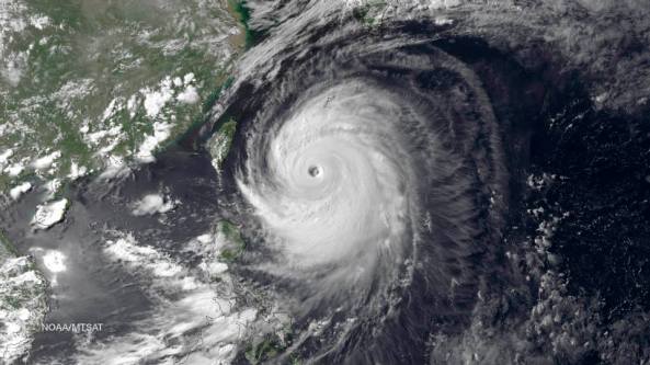
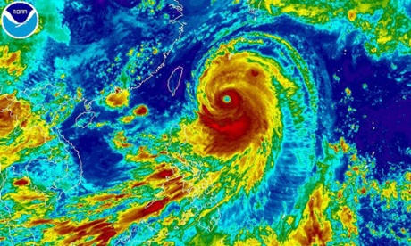
typhoon_neoguriThe violent super typhoon Neoguri is possibly the most powerful typhoon to strike Japan in 15 years. With expected wind gusts of 170 miles per hour and 75 millimetres of rain per hour the typhoon is battering the southern islands of Okinawa this morning.

Neoguri is forecast to continue northwards over land passing over the southern island of Kyushu and onto central Japan slowly losing energy along the way.

Typhoon Neoguri is carrying a huge amount of moisture. When it hits the mainland much of that will be released as rain, which could unleash flash floods and trigger landslides, our correspondent adds. Storm surge wave heights of 12 metres are expected raising fears of further coastal flooding.

Check out one of our earlier posts for a discussion of how these large cyclonic storms form.

Typhoon Neoguri, the first super typhoon of 2014. Source: EPA/NOAA

Typhoon Neoguri, the first super typhoon of 2014. Source: EPA/NOAA


More information:
[1] http://www.bbc.co.uk/news/world-asia-28189409
[2] https://climateandgeohazards.wordpress.com/2013/10/07/cyclones-hurricanes-and-typhoons-whats-the-difference


Image

Windstorm Xaver Hits Western Europe

Windstorm Xaver Hits Western Europe

Windstorm Xaver struck the coastal countries of western Europe on Thursday with gale force winds and intense rain. Thousands of people were evacuated from coastal towns and cities in the UK.
Wind gusts of more than 140 mph (225 km/h) were recorded in the Scottish Highlands on Thursday 5th December.
The Thames Barrier was shut to prevent flooding in the capital from, what is thought to be, potentially the worst storm surge in 60 years.

Luckily the improved flood defences, early warning systems and rapid action from the authorities helped minimise losses from the storm in the UK.

Image: Computer model showing a large area of high winds in the lower atmosphere, pushing the waters of the North Sea into the coasts around western Europe.
(Picture credit: WeatherBELL Analytics)

More information:
uk.reuters.com/article/2013/12/05/uk-europe-storm-idUKBRE9B40II20131205
http://www.ft.com/cms/s/0/c0274f94-5db5-11e3-95bd-00144feabdc0.html#axzz2mhL5WZBA

Image

Category 5 Super Typhoon Haiyan

Category 5 Super Typhoon Haiyan

With wind speeds of 195mph and a diameter exceeding 1000km the category 5 super typhoon Haiyan could well be the largest storm in history!

Although the record books are probably the last thing the people of Philippines are worried about right now as the storm ravages the country.
The above image from the Guardian website shows the expected path of the typhoon over the next few days. The storm is expected to decrease in strength as it moves across the South China Sea.

Cyclones, Hurricanes and Typhoons: What’s the difference?

Having now entered the second half of the Atlantic hurricane season I thought it time to write up a short post about these powerful natural events.

First we must resolve an important issue: what is the difference between cyclones, hurricanes and typhoons? The answer is: there is no difference! These are just different names for the same weather phenomenon originating in different geographic locations.

Tropical storms are characterised by their geographic origins. (NASA)

Tropical storms are characterised by their geographic origins. (NASA)

Hurricane Genesis

Hurricanes are very large storm whose birth originates in the tropical oceans. They rotate about a central axis commonly called ‘the eye’. The oceans are a massive source of heat energy. Variations in the sea surface temperature result in pressure differences in the atmosphere which cause storms to build up.

To be classified as a hurricane a storm must reach wind speeds of at least 74 miles per hour. The rotation of the Earth gives these storm their characteristic spiral shape. Cyclonic storms in the northern hemisphere rotate anticlockwise while those in the southern hemisphere rotate clockwise.

Hazards

The main hazards from hurricanes are strong winds (up to 150 miles per hour for the very large events) and high volumes of rain. Hurricane winds can uproot trees and destroy houses. Large amounts of rainfall in a short period of time result in floods and rising groundwater tables.

The water-clogged landscape remains unstable, with increased risk of landslides and surface failures for many years after a particularly large event. For example, there were increased number of landslides in Taiwan for 6 years after Cyclone Bhola.

Extensive damage after the 2005 hurricane Katrina. Total damage > $100 billion USD. (Mark Wolfe)

Extensive damage after the 2005 hurricane Katrina. Total damage > $100 billion USD.
(Mark Wolfe)

Historically significant hurricanes

The effect hurricanes have on people’s lives is depicted in the word hurricane itself; after the Caribbean god of evil, Hurrican. They are a devastating force of nature.

  • The 1970 Cyclone Bhola is historically the worst event for deaths with reported numbers as high as 500,000 people dead, mostly in Bangladesh.
  • Hurricane Katrina which struck the east coast of the U.S. in 2005 is the most costliest hurricane with overall damage exceeding $100 billion.
  • The 1979 Cyclone Tip was the most intense hurricane ever recorded with wind speeds around 190 miles per hour. It was also the largest hurricane with a diameter around 2,170 kilometres.
  • Hurricane Sandy (U.S. east coast, 2010) was an abnormally large event due to the fusion of a tropical hurricane and a winter storm. With rising temperatures due to global warming these hybrid-storms are expected to become more frequent.

What can we do?

Cyclone Mahasen hit Sri Lanka, Bangladesh and Burma earlier this season in May and resulted in far less deaths than expected thanks to swift action from the local governments. This shows that rapid response can save lives.

Proper preparation and sufficient warning can save thousands of lives every year. (Geoffrey Alan)

Proper preparation and sufficient warning can save thousands of lives every year.
(Geoffrey Alan)

Houses with appropriate shelters (as in the U.S.) need to be built in hurricane prone regions. Proper training should be given from early school level onwards on the appropriate actions to take before and after such events: e.g. having enough clean drinking water, tinned food, spare batteries for lights, mobile phone chargers, first aid kits etc.

Have a rapid response system in place from the national governmental level to manage pre-event evacuation (if needed) and post disaster recovery.

There is no clear agreement on what sort of affects climate change and global warming will have on hurricanes. However most scientists agree that the change will be for the worse whether it is in the form of increased number of hurricanes each year, increased size of the hurricanes or changes to the length of the hurricane season is uncertain.  We need to investment more into understanding the science behind these storms and the affects global warming will have on their magnitude and frequency of occurrence.

Ekbal

More information:
[1] National Hurricane Centre
[2] George M. Dunnavan & John W. Dierks (1980). An Analysis of Super Typhoon Tip (October 1979), Joint Typhoon Warning Center,1980
[3] www.weather.com/maps/news/atlstorm18/gulfofmexicosatellite_large.html

Video

Saharan dust cloud over the Atlantic reduces chance of hurricane formation


A massive dust storm forms over the Sahara and blows fine particulate dust over the Atlantic.

Dust acts as a shield and blocks sunlight from reaching the sea surface. In some cases the sea surface temperature can be reduced by 1°C from normal average temperatures. This has important consequences for hurricane and tropical cyclone formation which are very sensitive to sea surface temperatures.

It has been shown that large dust storms originating in the Sahara and blowing over the Atlantic can dramatically reduce the liklihood of tropical cyclone formation.

However there are large uncertainties in how African dust storms may change due to climate change. At present it is difficult to predict how dust emissions and transport may change over the next few decades due to global warming.

More info at :
http://www.wunderground.com/blog/JeffMasters/comment.html?entrynum=2478