When continents collide: Active deformation and seismic hazard

Since 1900, 35 earthquakes worldwide have each killed at least 10,000 people. Of these, 26 were in the Alpine-Himalayan seismic belt – a broad “crumple zone” where the African, Arabian and Indian tectonic plates collide with Europe and Asia. Most of these deadly earthquakes were caused by the rupture of faults that had not previously been identified.

CGS scientist Tim Wright is Professor of Satellite Geodesy at the University of Leeds and Director of the Natural Environment Research Council’s Centre for the Observation and Modelling of Earthquakes, Volcanoes and Tectonics (COMET). His work has been at the forefront of developing the use of satellite radar for measuring tectonic and volcanic deformation.

Tim was recently invited to present a guest lecture at the Geological Society on his work trying to understand the nature of seismic hazard within the Alpine-Himalayan region.

You can follow Tim on twitter: @timwright_leeds

Nepal earthquake lowered Everest by up to 2.5 cm

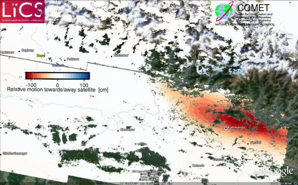
Further analysis of the newly processed sentinel-1 satellite radar data shows that the area around the Kathmandu region was uplifted in the earthquake, while the area to the north of Kathmandu sunk (subsided).

The red region in the image below shows uplift while the faint blues to the north indicate subsidence. Mount Everest is located to the northeast of Kathamndu.

Processed Sentinel 1 results of the Nepal earthquake deformation. red = mostly subsidence, blue = mostly uplift.  Source: Pablo Gonzalez – LiCS/COMET+

Processed Sentinel-1 results of the Nepal earthquake deformation. red = mostly uplift, blue = mostly subsidence.
Source: Pablo GonzalezLiCS/COMET+


The image was produced by COMET researchers at the University of Leeds as part of the Look Inside the Continents from Space (LiCS) project led by CGS scientist Professor Tim Wright.

New computer modelling results estimate that the amount of lowering experienced in the Everest region could be up to 2.5cm. These numbers are very preliminary and will be verified over the coming days with further research.

https://twitter.com/UNAVCO/status/593551340271378433

8 million in need of humanitarian aid in Nepal

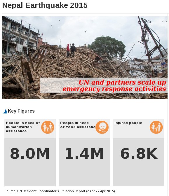
8 million people in need of humanitarian assistance in Nepal after a powerful magnitude 7.8 earthquake shook the country on April 25th, according to the United Nations Office for the Coordination of Humanitarian affairs (UN OCHA).

Key numbers in need of aid. Source: UN OCHA

Key numbers in need of aid.
Source: UN OCHA

Click on the image below for a link to how best to donate towards aid efforts in Nepal.

More information:
[1] http://www.unocha.org/nepal

Remembering the Colombia 1985 volcanic disaster

One of the most tragic volcanic events of the 20th century occurred in Colombia, in 1985, when an eruption of Nevado del Ruiz produced lahars that swept down river valleys and destroyed communities in its path. Over 20,000 people perished.

Mount Rainier and other volcanoes of the Pacific Northwest’s Cascade Range are similar to Nevado del Ruiz in many respects—massive amounts of snow and ice, a long history of lahars, and narrow valleys leading to populated areas. Could what happened at Nevado del Ruiz happen in the Pacific Northwest? And if it did, are we prepared?

In 2013, the US-Colombia Bi-national Exchange was created to help scientists, emergency managers and first responders in both countries to learn from the events in Colombia and to work toward improving disaster preparedness in communities located near volcanoes. The Exchange allows the Colombian officials to observe and learn about U.S. emergency response systems and for U.S. personnel to absorb the hard-earned lessons from the Colombians’ experiences with volcanic crises.

Scientists, decision-makers, emergency officials, community leaders, teachers, parents, students—everyone has a responsibility to prepare for the next eruption. Your role in preparedness begins with learning about the hazards where you live, work or go to school, evacuation routes and how to access information during a crisis. Ask local and state emergency officials and schools about their plans and be ready to follow their guidance. Finally, gather basic emergency provisions and create a plan to reunite with family members if you are separated. The volcano may erupt, but the tragedy doesn’t have to happen. And that is the point.

Disaster Charter activated for Villarrica volcano


A Red Alert has been declared in southern Chile after an eruption at Villarrica Volcano this morning.

Over two thousand people were evacuated from Pucon, and another thousand from Panguipulli, two communities close to the volcano.

While no one has been harmed in the eruption, the situation will continue to be monitored for any further eruption. The ash from the volcano could also pose a hazard to health. Meteorologists currently expect the ash cloud to be blown south and across remote parts of Argentina.

disaster_charterThe Disaster Charter is an agreement between international satellite and remote sensing agencies to provide free access to data and resources to help mitigate the effects of disasters on human life and property.

The Charter can be activated by any national disaster management authority. The activation for Villarrica was requested by the  Chilean agency responsible for civil protection (ONEMI, Oficina Nacional de Emergencia del Ministerio del Interior y Seguridad Pública).

For updates of the ongoing activity check the latest status reports from ONEMI, Chile. Also, follow #Villarrica on twitter for social media updates and more images of the current activity.

Video

Twin Tornadoes hit Nebraska, United States

Twin tornadoes are an exceptionally rare weather phenomenon. Two large tornadoes hit the town of Pilger in the U.S. state of Nebraska last Monday, 16th June.

The video above shows the two violent tornadoes ripping through the countryside. The BBC reports that at least one person is dead and at least 19 are hurt.

Check out our earlier post for more information on tornadoes, how they form and how their strength is calculated.

Tornadoes: Rotating Destruction

A tornado is a violently rotating column of air that is in contact with both the surface of the Earth and a large rain cloud.

Most tornadoes have wind speeds less than 110 miles per hour, are about 76 metres across, and travel several kilometers before losing all its energy and dissipating. However, some extreme tornadoes can attain wind speeds of more than 300 miles per hour, stretch more than two miles across, and stay on the ground for more than 100 km!

These violent weather events can rip paths of destruction through towns and cities and kill large numbers of people.

Tornado Formation
Although, no two tornadoes are the same, they all need certain conditions before they can form – particularly intense heat.

Winds from different directions cause the rising air to rotate. Source: BBC

Winds from different directions cause the rising air to rotate.
Source: BBC

  • As the ground temperature increases, warm, wet air heats up and starts to rise.
  • When this warm, moist, air meets cold dry air, it explodes upwards, puncturing the air layer above. At this stage a thunder cloud may begin to build.
  • This develops into a storm – there may be rain, thunder and lightning.
  • Winds from different  directions can case the upward moving air to rotate
  • This forms the characteristic cone shape we associate with tornadoes.

Tornado Strength Scale
There are several scales for rating the strength of tornadoes. The Enhanced Fujita Scale (EFS) rates tornadoes by the amount of damage caused by the tornado. This is the most common rating scale used by most countries.

The Enhanced Fujita Scale splits tornado strength into six categories.

The Enhanced Fujita Scale for tornadoes

The Enhanced Fujita Scale for tornadoes


Tornadoes have been observed on every continent except Antarctica. However, the vast majority of tornadoes occur in the Tornado Alley region of the United States.

Ekbal

More Information:
[1] http://news.bbc.co.uk/1/hi/in_depth/5328524.stm

Image

Natural hazards education in the Himalayas

Natural hazards education in the Himalayas

It’s a big month as the Geology for Global Development team embark on a major natural hazards education and sustainable development project in the Himalayas.

The project (part of a broader sustainable development project in the Himalayas) will be aiming to:

  1. Share our knowledge and expertise,
  2. Learn from others about aspects of best practice in both understanding science and understanding culture and social development,
  3. Identify practical skills development opportunities for students in the UK.

CGS academics are also involved with this project. Professor Tim Wright will be giving a keynote lecture at the conference in India later next week and Ekbal Hussain has contributed to a booklet that will be used to teach school children about natural hazards in the Himalaya region (above image).

Read more about the project here:
http://blogs.egu.eu/gfgd/2014/06/09/gfgd-in-the-himalaya-1-project-overview

Ekbal