When continents collide: Active deformation and seismic hazard

Since 1900, 35 earthquakes worldwide have each killed at least 10,000 people. Of these, 26 were in the Alpine-Himalayan seismic belt – a broad “crumple zone” where the African, Arabian and Indian tectonic plates collide with Europe and Asia. Most of these deadly earthquakes were caused by the rupture of faults that had not previously been identified.

CGS scientist Tim Wright is Professor of Satellite Geodesy at the University of Leeds and Director of the Natural Environment Research Council’s Centre for the Observation and Modelling of Earthquakes, Volcanoes and Tectonics (COMET). His work has been at the forefront of developing the use of satellite radar for measuring tectonic and volcanic deformation.

Tim was recently invited to present a guest lecture at the Geological Society on his work trying to understand the nature of seismic hazard within the Alpine-Himalayan region.

You can follow Tim on twitter: @timwright_leeds

Nepal earthquake lowered Everest by up to 2.5 cm

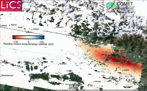
Further analysis of the newly processed sentinel-1 satellite radar data shows that the area around the Kathmandu region was uplifted in the earthquake, while the area to the north of Kathmandu sunk (subsided).

The red region in the image below shows uplift while the faint blues to the north indicate subsidence. Mount Everest is located to the northeast of Kathamndu.

Processed Sentinel 1 results of the Nepal earthquake deformation. red = mostly subsidence, blue = mostly uplift.  Source: Pablo Gonzalez – LiCS/COMET+

Processed Sentinel-1 results of the Nepal earthquake deformation. red = mostly uplift, blue = mostly subsidence.
Source: Pablo GonzalezLiCS/COMET+


The image was produced by COMET researchers at the University of Leeds as part of the Look Inside the Continents from Space (LiCS) project led by CGS scientist Professor Tim Wright.

New computer modelling results estimate that the amount of lowering experienced in the Everest region could be up to 2.5cm. These numbers are very preliminary and will be verified over the coming days with further research.

https://twitter.com/UNAVCO/status/593551340271378433

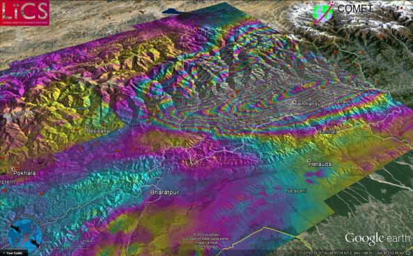
Clearer sentinel 1 image of Nepal earthquake deformation

A new clearer sentinel 1 satellite image has been produced by COMET researchers as part of the Look Inside the Continents from Space (LiCS) project led by CGS scientist Professor Tim Wright.

For Tim Wright’s preliminary interpretation of the results see our previous post.

Sentinel 1 image of the Nepal earthquake deformation. Source: John Elliot - LiCS/COMET

Sentinel 1 image of the Nepal earthquake deformation. 1 colour fringe = 10cm of ground deformation.
Source: John ElliotLiCS/COMET+

8 million in need of humanitarian aid in Nepal

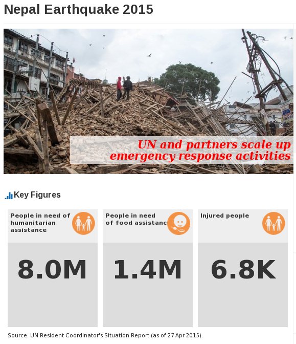
8 million people in need of humanitarian assistance in Nepal after a powerful magnitude 7.8 earthquake shook the country on April 25th, according to the United Nations Office for the Coordination of Humanitarian affairs (UN OCHA).

Key numbers in need of aid. Source: UN OCHA

Key numbers in need of aid.
Source: UN OCHA

Click on the image below for a link to how best to donate towards aid efforts in Nepal.

More information:
[1] http://www.unocha.org/nepal

Disaster Charter activated for Villarrica volcano


A Red Alert has been declared in southern Chile after an eruption at Villarrica Volcano this morning.

Over two thousand people were evacuated from Pucon, and another thousand from Panguipulli, two communities close to the volcano.

While no one has been harmed in the eruption, the situation will continue to be monitored for any further eruption. The ash from the volcano could also pose a hazard to health. Meteorologists currently expect the ash cloud to be blown south and across remote parts of Argentina.

disaster_charterThe Disaster Charter is an agreement between international satellite and remote sensing agencies to provide free access to data and resources to help mitigate the effects of disasters on human life and property.

The Charter can be activated by any national disaster management authority. The activation for Villarrica was requested by the  Chilean agency responsible for civil protection (ONEMI, Oficina Nacional de Emergencia del Ministerio del Interior y Seguridad Pública).

For updates of the ongoing activity check the latest status reports from ONEMI, Chile. Also, follow #Villarrica on twitter for social media updates and more images of the current activity.

Using satellites to map ground movements on Fogo volcano

The Fogo volcano, named after the Cape Verde island it inhabits, erupted on 23rd November for the first time in 19 years. Initial analysis suggests that there was little warning from the volcano before the eruption and surprised many local residents. The volcano is still currently active and the locals have been evacuated.

The volcano expelled a large quantity of lava which flowed towards a nearby village. About 20 homes were destroyed

Researchers at the University of Leeds, School of Earth and Environment (Pablo Gonzalez) and PPO.labs (Petar Marincovic) in the Netherlands have been busy analysing satellite radar data from the European Space Agency’s new Sentinel-1A satellite, which launched earlier this year in April.

Preliminary results show the movement of the ground on and around the volcano shown by the rainbow colours on the radar deformation map shown below.

Surface deformation map of the Fogo island volcano that erupted recently.  Source: ESA

Surface deformation map of the Fogo island volcano that erupted recently.
Source: ESA

The use of satellites, such as Sentinel-1A, will allow for a much greater number of volcanoes to be monitored on a regular basis. This is particularly valuable in places with few sensors on the ground. The data acquisition rates are expected to increase further with the launch of the next suite of Sentinel satellites from the European Space agency over the next few years.

“By acquiring regular images from Sentinel-1, we will be able to monitor magma movement in the subsurface, even before eruptions take place, and use the data to provide warnings,” said Tim Wright from the University of Leeds and director of the UK Natural Environment Research Council’s Centre for the Observation and Modelling of Earthquakes, Volcanoes and Tectonics. (quote source)

“The coverage and repeat visit time of Sentinel-1 is unprecedented and we are currently working on a system that will use Sentinel-1 to monitor all of the visible volcanoes in the world,” said Andy Hooper, also from the University of Leeds. (quote source)

More information:
[1] http://www.esa.int/Our_Activities/Observing_the_Earth/Copernicus/Sentinel-1/Fogo_volcano_on_Sentinel_s_radar
[2] http://www.esa.int/spaceinimages/Images/2014/12/Mapping_for_emergency_response
[3] http://www.esa.int/spaceinimages/Images/2014/12/Sentinel-1_maps_Fogo_eruption
[4] http://www.bbc.co.uk/news/world-africa-30291041

Haiti – An engineering disaster

The 2010 earthquake in Haiti was one of the greatest seismic tragedies of the last few decades. The magnitude 7 struck late in the afternoon with an epicentre just west the capital Port-au-Prince on 12th January 2010.

The earthquake caused major damage in the capital and surrounding regions leaving a death toll estimated between 100,000 and 316,000. Most of these deaths occurred due to the collapse of buildings and other infrastructure.

TED Fellow Peter Haas explains why Haiti was not a natural disaster but a disaster of engineering in his TED talk, linked below.

EGU 2014: The Landscape Detectives – Searching for prehistoric earthquakes

20140429-103457.jpgThe annual European Geoscience Union meeting is the largest conference gathering of geoscientists in Europe. Held in the historic city of Vienna, the meeting brings together a diverse range of scientists, students and professionals to share and exchange their research and ideas.

Many CGS academics and students from the University of Leeds are attending this year’s event. For the next week or so I’ll be writing a few short posts about some of the talks that catch, my eye from the Natural Hazards sessions. The first in the EGU series of posts is about playing detective with the landscape and is based on a talk given by COMET+ scientist Richard Walker.

Earthquakes are caused by the sudden release of energy by movements along large fractures in the Earth called faults. These events release a lot of seismic energy that spreads away from the fault. These are what causes damage to buildings and the landscape. Earthquakes can be very destructive events, as we saw in 2010 when a magnitude 7.1earthquake in Haiti killed almost 230,000 people!

An earthquake rupture preserved in the landscape in Mongolia. Image courtesy of Richard Walker.

An earthquake rupture preserved in the landscape in Mongolia. Image courtesy of Richard Walker.

It is important to understand the history of earthquakes along large faults if we are to accurately understand its behaviour and be able to make reliable forecasts of the hazards it might pose. However, the historical record of past activity on large faults is very sparse. Particularly in regions around Central Asia where populations have historically been small and/or nomadic.

This is where the landscape detectives come in. Every large earthquake results in movements along faults. Very often these movements are preserved in the landscape. This might be in the form of an uplifted river terrace, a diverted stream, an offset hill etc.

The landscape detectives, or geomorphologist to use the technical term, hunt for these clues and gather evidence for past movements along faults and try to determine the size of the movements and when it occurred. Using these they can give an estimate of the size of the earthquake that caused the event and more importantly add constraints on how fast the fault is moving. All these are are vital if we are to understand the fault and forecasts it’s behaviour in the future.

If you would like more information be sure to send us an email. I will write a more detailed feature on the actual techniques used by geomorphologists to untangle the earthquake history from the landscape after the conference.

Ekbal